
William F. Hayden Park Plan
Join the Community Conversation
The results are in! View the public survey results and neighborhood survey results for the William F. Hayden Plan. Did you miss the final survey for the plan? No problem, you can review the survey information and draft Trails Concept Plan (large file) and ask a question of the project team. The draft plan will be posted later this fall for additional community feedback. Be sure to subscribe to the page for updates.
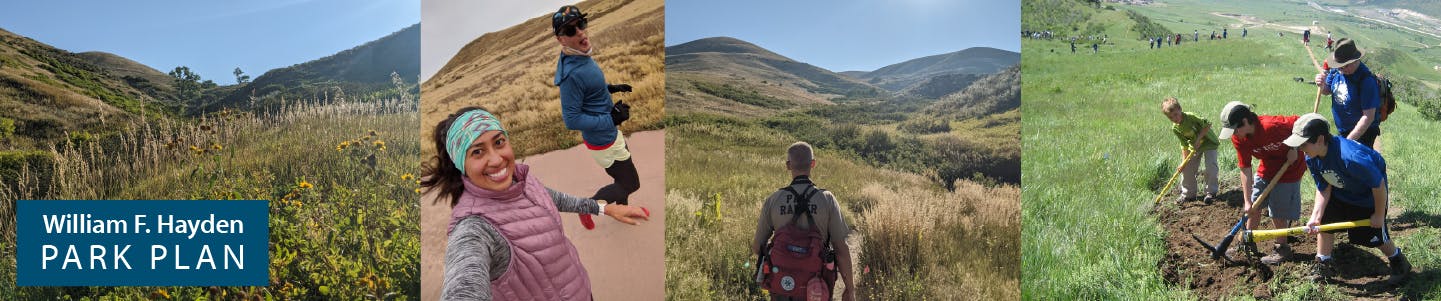
Elevate your everyday at William F. Hayden Park, Lakewood's popular regional park destination providing access to nature and an opportunity get outdoors and take in the views! Join us for a community conversation to better understand the park's wildlife and natural resources while gaining valuable insight into what park visitors love and what they would like to see improved.
Managed by the City of Lakewood, the park is beginning a comprehensive planning process that will include an assessment of park visitor needs, an evaluation of park trails and infrastructure, environmental review, recreation management, and design work for future park and trail improvements. These will be packaged into an implementable action plan to serve visitors for the next decade. The city hired DHM Design to lead the projected 12-month planning effort, which will include an extensive public engagement process with park visitors and stakeholders.
About William F. Hayden Park
With more than 2,400 acres of open space, William Frederick Hayden Park on Green Mountain is the second largest park in Lakewood. The park features a challenging network of shared use trails, with a 6,800-foot summit up Green Mountain Trail offering unique and stunning views of the Denver metropolitan area to the east and high mountain peaks to the west.
Beginning 1972, the majority of William Frederick Hayden Park was donated by or purchased from the Hayden family. Once home to the buffalo, this park now provides rich habitat for a diverse array of wildlife including coyotes, hawks, rattlesnakes, bluebirds, rabbit, mule deer and an occasional mountain lion.

We want to hear from you!
Subscribe to this page for updates, meeting notices and other opportunities to participate in the future of this special park. Use the tools below to ask a question of the project team or share an idea for the park.
Join the Community Conversation
The results are in! View the public survey results and neighborhood survey results for the William F. Hayden Plan. Did you miss the final survey for the plan? No problem, you can review the survey information and draft Trails Concept Plan (large file) and ask a question of the project team. The draft plan will be posted later this fall for additional community feedback. Be sure to subscribe to the page for updates.
Elevate your everyday at William F. Hayden Park, Lakewood's popular regional park destination providing access to nature and an opportunity get outdoors and take in the views! Join us for a community conversation to better understand the park's wildlife and natural resources while gaining valuable insight into what park visitors love and what they would like to see improved.
Managed by the City of Lakewood, the park is beginning a comprehensive planning process that will include an assessment of park visitor needs, an evaluation of park trails and infrastructure, environmental review, recreation management, and design work for future park and trail improvements. These will be packaged into an implementable action plan to serve visitors for the next decade. The city hired DHM Design to lead the projected 12-month planning effort, which will include an extensive public engagement process with park visitors and stakeholders.
About William F. Hayden Park
With more than 2,400 acres of open space, William Frederick Hayden Park on Green Mountain is the second largest park in Lakewood. The park features a challenging network of shared use trails, with a 6,800-foot summit up Green Mountain Trail offering unique and stunning views of the Denver metropolitan area to the east and high mountain peaks to the west.
Beginning 1972, the majority of William Frederick Hayden Park was donated by or purchased from the Hayden family. Once home to the buffalo, this park now provides rich habitat for a diverse array of wildlife including coyotes, hawks, rattlesnakes, bluebirds, rabbit, mule deer and an occasional mountain lion.
We want to hear from you!
Subscribe to this page for updates, meeting notices and other opportunities to participate in the future of this special park. Use the tools below to ask a question of the project team or share an idea for the park.
Ask a question
Have a question about the William F. Hayden Park planning effort? Ask the project team here.
-
Share I am wondering if you are aware of the proposed private backyard pickleball court that was approved by the Mesa View Estates HOA at 170 S. Kilmer St. The property abuts the William F Hayden North Trail. This will cause irreputable damage to the peaceful hiking trails and displace wildlife. The property sits at the bottom of the hill so the noise will cause and amphitheater effect. The high-frequency pop from the pickleball paddles will carry up and bounce off of the hill causing an echo that will be heard near and far. • Disruption of Songbirds: Green Mountain is home to numerous nesting and migratory birds. Birds rely on distinct acoustic frequencies to communicate, establish territory, and attract mates. The repetitive, loud thwack of pickleball falls precisely into the acoustic frequencies birds use, masking their songs and forcing them to alter their calls or abandon nesting sites near the park boundary. • The "Predator Alert" Response: Unlike steady highway noise, pickleball creates an impulsive, erratic rhythm. Mammals like deer, coyotes, and small rodents perceive these sudden, sharp sounds as potential threats. This keeps animals in a constant state of hyper-vigilance, triggering their flight response and driving them away from crucial foraging grounds near the neighborhood edge. • Habitat Fragmentation: Noise pollution effectively shrinks the usable size of a nature preserve. Even if the physical land remains untouched, a zone of constant, harsh sound creates an invisible barrier that sensitive wildlife species will actively avoid, fracturing the ecosystem along the Kilmer Street border. This wil be in clear violation of the Unincorporated Jefferson County Noise Abatement Policy but the HOA is letting it go ahead because "building a court is not illegal". And no nuisance noise has occurred yet. I have written many emails to the City of Lakewood, Mayor, representatives, Jefferson County Open Space, Aaron Roth, and countless others and I am not getting a response or any help stopping this from happening. Can you help save this side of the mountain or direct me to someone who can? Thank you for listening! on Facebook Share I am wondering if you are aware of the proposed private backyard pickleball court that was approved by the Mesa View Estates HOA at 170 S. Kilmer St. The property abuts the William F Hayden North Trail. This will cause irreputable damage to the peaceful hiking trails and displace wildlife. The property sits at the bottom of the hill so the noise will cause and amphitheater effect. The high-frequency pop from the pickleball paddles will carry up and bounce off of the hill causing an echo that will be heard near and far. • Disruption of Songbirds: Green Mountain is home to numerous nesting and migratory birds. Birds rely on distinct acoustic frequencies to communicate, establish territory, and attract mates. The repetitive, loud thwack of pickleball falls precisely into the acoustic frequencies birds use, masking their songs and forcing them to alter their calls or abandon nesting sites near the park boundary. • The "Predator Alert" Response: Unlike steady highway noise, pickleball creates an impulsive, erratic rhythm. Mammals like deer, coyotes, and small rodents perceive these sudden, sharp sounds as potential threats. This keeps animals in a constant state of hyper-vigilance, triggering their flight response and driving them away from crucial foraging grounds near the neighborhood edge. • Habitat Fragmentation: Noise pollution effectively shrinks the usable size of a nature preserve. Even if the physical land remains untouched, a zone of constant, harsh sound creates an invisible barrier that sensitive wildlife species will actively avoid, fracturing the ecosystem along the Kilmer Street border. This wil be in clear violation of the Unincorporated Jefferson County Noise Abatement Policy but the HOA is letting it go ahead because "building a court is not illegal". And no nuisance noise has occurred yet. I have written many emails to the City of Lakewood, Mayor, representatives, Jefferson County Open Space, Aaron Roth, and countless others and I am not getting a response or any help stopping this from happening. Can you help save this side of the mountain or direct me to someone who can? Thank you for listening! on X (formerly Twitter) Share I am wondering if you are aware of the proposed private backyard pickleball court that was approved by the Mesa View Estates HOA at 170 S. Kilmer St. The property abuts the William F Hayden North Trail. This will cause irreputable damage to the peaceful hiking trails and displace wildlife. The property sits at the bottom of the hill so the noise will cause and amphitheater effect. The high-frequency pop from the pickleball paddles will carry up and bounce off of the hill causing an echo that will be heard near and far. • Disruption of Songbirds: Green Mountain is home to numerous nesting and migratory birds. Birds rely on distinct acoustic frequencies to communicate, establish territory, and attract mates. The repetitive, loud thwack of pickleball falls precisely into the acoustic frequencies birds use, masking their songs and forcing them to alter their calls or abandon nesting sites near the park boundary. • The "Predator Alert" Response: Unlike steady highway noise, pickleball creates an impulsive, erratic rhythm. Mammals like deer, coyotes, and small rodents perceive these sudden, sharp sounds as potential threats. This keeps animals in a constant state of hyper-vigilance, triggering their flight response and driving them away from crucial foraging grounds near the neighborhood edge. • Habitat Fragmentation: Noise pollution effectively shrinks the usable size of a nature preserve. Even if the physical land remains untouched, a zone of constant, harsh sound creates an invisible barrier that sensitive wildlife species will actively avoid, fracturing the ecosystem along the Kilmer Street border. This wil be in clear violation of the Unincorporated Jefferson County Noise Abatement Policy but the HOA is letting it go ahead because "building a court is not illegal". And no nuisance noise has occurred yet. I have written many emails to the City of Lakewood, Mayor, representatives, Jefferson County Open Space, Aaron Roth, and countless others and I am not getting a response or any help stopping this from happening. Can you help save this side of the mountain or direct me to someone who can? Thank you for listening! on Linkedin Email I am wondering if you are aware of the proposed private backyard pickleball court that was approved by the Mesa View Estates HOA at 170 S. Kilmer St. The property abuts the William F Hayden North Trail. This will cause irreputable damage to the peaceful hiking trails and displace wildlife. The property sits at the bottom of the hill so the noise will cause and amphitheater effect. The high-frequency pop from the pickleball paddles will carry up and bounce off of the hill causing an echo that will be heard near and far. • Disruption of Songbirds: Green Mountain is home to numerous nesting and migratory birds. Birds rely on distinct acoustic frequencies to communicate, establish territory, and attract mates. The repetitive, loud thwack of pickleball falls precisely into the acoustic frequencies birds use, masking their songs and forcing them to alter their calls or abandon nesting sites near the park boundary. • The "Predator Alert" Response: Unlike steady highway noise, pickleball creates an impulsive, erratic rhythm. Mammals like deer, coyotes, and small rodents perceive these sudden, sharp sounds as potential threats. This keeps animals in a constant state of hyper-vigilance, triggering their flight response and driving them away from crucial foraging grounds near the neighborhood edge. • Habitat Fragmentation: Noise pollution effectively shrinks the usable size of a nature preserve. Even if the physical land remains untouched, a zone of constant, harsh sound creates an invisible barrier that sensitive wildlife species will actively avoid, fracturing the ecosystem along the Kilmer Street border. This wil be in clear violation of the Unincorporated Jefferson County Noise Abatement Policy but the HOA is letting it go ahead because "building a court is not illegal". And no nuisance noise has occurred yet. I have written many emails to the City of Lakewood, Mayor, representatives, Jefferson County Open Space, Aaron Roth, and countless others and I am not getting a response or any help stopping this from happening. Can you help save this side of the mountain or direct me to someone who can? Thank you for listening! link
I am wondering if you are aware of the proposed private backyard pickleball court that was approved by the Mesa View Estates HOA at 170 S. Kilmer St. The property abuts the William F Hayden North Trail. This will cause irreputable damage to the peaceful hiking trails and displace wildlife. The property sits at the bottom of the hill so the noise will cause and amphitheater effect. The high-frequency pop from the pickleball paddles will carry up and bounce off of the hill causing an echo that will be heard near and far. • Disruption of Songbirds: Green Mountain is home to numerous nesting and migratory birds. Birds rely on distinct acoustic frequencies to communicate, establish territory, and attract mates. The repetitive, loud thwack of pickleball falls precisely into the acoustic frequencies birds use, masking their songs and forcing them to alter their calls or abandon nesting sites near the park boundary. • The "Predator Alert" Response: Unlike steady highway noise, pickleball creates an impulsive, erratic rhythm. Mammals like deer, coyotes, and small rodents perceive these sudden, sharp sounds as potential threats. This keeps animals in a constant state of hyper-vigilance, triggering their flight response and driving them away from crucial foraging grounds near the neighborhood edge. • Habitat Fragmentation: Noise pollution effectively shrinks the usable size of a nature preserve. Even if the physical land remains untouched, a zone of constant, harsh sound creates an invisible barrier that sensitive wildlife species will actively avoid, fracturing the ecosystem along the Kilmer Street border. This wil be in clear violation of the Unincorporated Jefferson County Noise Abatement Policy but the HOA is letting it go ahead because "building a court is not illegal". And no nuisance noise has occurred yet. I have written many emails to the City of Lakewood, Mayor, representatives, Jefferson County Open Space, Aaron Roth, and countless others and I am not getting a response or any help stopping this from happening. Can you help save this side of the mountain or direct me to someone who can? Thank you for listening!
CJ asked 22 days agoThank you for your feedback, this information was included with the service request you had already submitted.
-
Share Realized I just missed the survey deadline by a day. Any way I can take a survey or get signed up for info? I’m a nearby resident, hiker, biker, and outdoor enthusiast and green mountain is 10 minutes away by bike on Facebook Share Realized I just missed the survey deadline by a day. Any way I can take a survey or get signed up for info? I’m a nearby resident, hiker, biker, and outdoor enthusiast and green mountain is 10 minutes away by bike on X (formerly Twitter) Share Realized I just missed the survey deadline by a day. Any way I can take a survey or get signed up for info? I’m a nearby resident, hiker, biker, and outdoor enthusiast and green mountain is 10 minutes away by bike on Linkedin Email Realized I just missed the survey deadline by a day. Any way I can take a survey or get signed up for info? I’m a nearby resident, hiker, biker, and outdoor enthusiast and green mountain is 10 minutes away by bike link
Realized I just missed the survey deadline by a day. Any way I can take a survey or get signed up for info? I’m a nearby resident, hiker, biker, and outdoor enthusiast and green mountain is 10 minutes away by bike
KeithK asked 3 months agoHi Keith,
Absolutely, you are welcome to email the project team any questions or ideas or share via the tools on this page. You can find plan materials here and here. Keep in mind that the survey that recently closed informs the draft plan which will be posted on this project page this summer for community feedback. You can subscribe to the page to receive updates!
-
Share I would like to better understand the percentage of Green Mountain recreational users that live within a 5 mile radius of the mountain. Are local users more prevalent than others? Have you assessed the impact of the redesign to the local community and traffic? Also, what is the percentage of users of the mountain that are on foot vs hiking etc? And how does the proposed plan address these groups adequately? on Facebook Share I would like to better understand the percentage of Green Mountain recreational users that live within a 5 mile radius of the mountain. Are local users more prevalent than others? Have you assessed the impact of the redesign to the local community and traffic? Also, what is the percentage of users of the mountain that are on foot vs hiking etc? And how does the proposed plan address these groups adequately? on X (formerly Twitter) Share I would like to better understand the percentage of Green Mountain recreational users that live within a 5 mile radius of the mountain. Are local users more prevalent than others? Have you assessed the impact of the redesign to the local community and traffic? Also, what is the percentage of users of the mountain that are on foot vs hiking etc? And how does the proposed plan address these groups adequately? on Linkedin Email I would like to better understand the percentage of Green Mountain recreational users that live within a 5 mile radius of the mountain. Are local users more prevalent than others? Have you assessed the impact of the redesign to the local community and traffic? Also, what is the percentage of users of the mountain that are on foot vs hiking etc? And how does the proposed plan address these groups adequately? link
I would like to better understand the percentage of Green Mountain recreational users that live within a 5 mile radius of the mountain. Are local users more prevalent than others? Have you assessed the impact of the redesign to the local community and traffic? Also, what is the percentage of users of the mountain that are on foot vs hiking etc? And how does the proposed plan address these groups adequately?
Connie H asked 3 months agoHi there,
Thank you for your question! The project team has analyzed trail counter data on the mountain and Strava data, but this only represents how the mountain is being used, not where visitors are coming from. That said, the consultant has completed a Recreation Suitability Analysis that identifies local and regional use and compares user needs. This information will inform the capacity analysis and operational strategies that will be included in the William F. Hayden plan to be completed this summer. You will be able to learn more and comment on the draft plan by visiting this project page.
Traffic on the mountain is 80% on foot and 20% on wheels. This information is carefully utilized as the project team works through Conceptual Trails. This plan is not yet funded, but serves as a guiding document for the next 10-20 years. Separating user groups has been highly favored to date through the public engagement process from both hikers and bikers.
Hope this helps answer some of your questions!
-
Share To date, limited information has been provided regarding neighborhood impact studies, wildlife impact management strategies, enforcement plans, implementation costs, long-term maintenance funding, and phased development. Could you please provide a comprehensive update on these items and clarify the expected deliverables from the planning committee? on Facebook Share To date, limited information has been provided regarding neighborhood impact studies, wildlife impact management strategies, enforcement plans, implementation costs, long-term maintenance funding, and phased development. Could you please provide a comprehensive update on these items and clarify the expected deliverables from the planning committee? on X (formerly Twitter) Share To date, limited information has been provided regarding neighborhood impact studies, wildlife impact management strategies, enforcement plans, implementation costs, long-term maintenance funding, and phased development. Could you please provide a comprehensive update on these items and clarify the expected deliverables from the planning committee? on Linkedin Email To date, limited information has been provided regarding neighborhood impact studies, wildlife impact management strategies, enforcement plans, implementation costs, long-term maintenance funding, and phased development. Could you please provide a comprehensive update on these items and clarify the expected deliverables from the planning committee? link
To date, limited information has been provided regarding neighborhood impact studies, wildlife impact management strategies, enforcement plans, implementation costs, long-term maintenance funding, and phased development. Could you please provide a comprehensive update on these items and clarify the expected deliverables from the planning committee?
T.Graham asked 3 months agoHi there,
Thank you for your question. Extensive study has been completed on the mountain including ecological and cultural surveys, along with studies of use patterns. Presentation boards and FAQ from the last Open House are available here with more information.
As this plan is a guiding document for the next 10-20 years, funding has not yet been designated. The draft plan will be available for public review this summer and include operational strategies, phasing and cost estimates, along with resource needs. In addition, initial concepts, including a 10-space parking lot at the Alkire Trailhead has been removed due to concerns voiced from the nearby neighborhood. There is no available funding at this time to implement the plan and further design and impact studies will be required as phases are funded and moved to implementation.
Planning process information is also available on this project page under the Documents section. Let us know if you have additional questions.
-
Share My name is Erin, and I live in Green Mountain Estates. William F. Hayden Park on Green Mountain is truly an extension of our home. My husband and I are frequent trail runners, and our two young boys are constantly out hiking these trails with us. I recently saw proposed changes that include expanding bike-only trails, and I want to be very clear—this is incredibly frustrating to see given the current conditions on the mountain. I run on these trails almost daily, and there has not been a single time I have gone out without encountering multiple mountain bikers who do not yield. Not once. This is not an occasional issue—it is consistent and widespread. Every person I know who uses this trail feels this way. There are already signs clearly stating that bikers must yield to hikers and horses. The reality is, those rules are routinely ignored. If the existing rules are not being respected, adding more bike-specific infrastructure without addressing that behavior feels completely misaligned with what is actually happening on the ground. I have made an effort to address this politely when it happens, and more often than not I am met with defensiveness, hostility, or dismissive behavior. As someone who is frequently out there with young children, that is not just frustrating—it is concerning. It is also concerning being a women and getting threatened by a man on a bike when the are the ones disobeying the rules. Because of this, I strongly believe there needs to be a much larger push for: Designated foot-traffic-only trails (priority over bike traffic only) Real separation between user groups to improve safety Consideration of limiting bike access in high foot-traffic areas Expanding trail access is a great goal—but it should be done in a way that works for everyone, not just one user group. Right now, the balance is not there. This is also about preservation. The level of bike traffic is clearly contributing to wear and erosion in many areas. Protecting portions of the mountain for foot traffic only would help preserve the land while also creating a safer, more respectful environment. I care deeply about this park and want to see it improved in a way that reflects how it is actually being used today—not just how it is intended to be used. I strongly urge the City to prioritize safety, accountability, and dedicated space for hikers and families as part of this plan. Thank you for your time and consideration. on Facebook Share My name is Erin, and I live in Green Mountain Estates. William F. Hayden Park on Green Mountain is truly an extension of our home. My husband and I are frequent trail runners, and our two young boys are constantly out hiking these trails with us. I recently saw proposed changes that include expanding bike-only trails, and I want to be very clear—this is incredibly frustrating to see given the current conditions on the mountain. I run on these trails almost daily, and there has not been a single time I have gone out without encountering multiple mountain bikers who do not yield. Not once. This is not an occasional issue—it is consistent and widespread. Every person I know who uses this trail feels this way. There are already signs clearly stating that bikers must yield to hikers and horses. The reality is, those rules are routinely ignored. If the existing rules are not being respected, adding more bike-specific infrastructure without addressing that behavior feels completely misaligned with what is actually happening on the ground. I have made an effort to address this politely when it happens, and more often than not I am met with defensiveness, hostility, or dismissive behavior. As someone who is frequently out there with young children, that is not just frustrating—it is concerning. It is also concerning being a women and getting threatened by a man on a bike when the are the ones disobeying the rules. Because of this, I strongly believe there needs to be a much larger push for: Designated foot-traffic-only trails (priority over bike traffic only) Real separation between user groups to improve safety Consideration of limiting bike access in high foot-traffic areas Expanding trail access is a great goal—but it should be done in a way that works for everyone, not just one user group. Right now, the balance is not there. This is also about preservation. The level of bike traffic is clearly contributing to wear and erosion in many areas. Protecting portions of the mountain for foot traffic only would help preserve the land while also creating a safer, more respectful environment. I care deeply about this park and want to see it improved in a way that reflects how it is actually being used today—not just how it is intended to be used. I strongly urge the City to prioritize safety, accountability, and dedicated space for hikers and families as part of this plan. Thank you for your time and consideration. on X (formerly Twitter) Share My name is Erin, and I live in Green Mountain Estates. William F. Hayden Park on Green Mountain is truly an extension of our home. My husband and I are frequent trail runners, and our two young boys are constantly out hiking these trails with us. I recently saw proposed changes that include expanding bike-only trails, and I want to be very clear—this is incredibly frustrating to see given the current conditions on the mountain. I run on these trails almost daily, and there has not been a single time I have gone out without encountering multiple mountain bikers who do not yield. Not once. This is not an occasional issue—it is consistent and widespread. Every person I know who uses this trail feels this way. There are already signs clearly stating that bikers must yield to hikers and horses. The reality is, those rules are routinely ignored. If the existing rules are not being respected, adding more bike-specific infrastructure without addressing that behavior feels completely misaligned with what is actually happening on the ground. I have made an effort to address this politely when it happens, and more often than not I am met with defensiveness, hostility, or dismissive behavior. As someone who is frequently out there with young children, that is not just frustrating—it is concerning. It is also concerning being a women and getting threatened by a man on a bike when the are the ones disobeying the rules. Because of this, I strongly believe there needs to be a much larger push for: Designated foot-traffic-only trails (priority over bike traffic only) Real separation between user groups to improve safety Consideration of limiting bike access in high foot-traffic areas Expanding trail access is a great goal—but it should be done in a way that works for everyone, not just one user group. Right now, the balance is not there. This is also about preservation. The level of bike traffic is clearly contributing to wear and erosion in many areas. Protecting portions of the mountain for foot traffic only would help preserve the land while also creating a safer, more respectful environment. I care deeply about this park and want to see it improved in a way that reflects how it is actually being used today—not just how it is intended to be used. I strongly urge the City to prioritize safety, accountability, and dedicated space for hikers and families as part of this plan. Thank you for your time and consideration. on Linkedin Email My name is Erin, and I live in Green Mountain Estates. William F. Hayden Park on Green Mountain is truly an extension of our home. My husband and I are frequent trail runners, and our two young boys are constantly out hiking these trails with us. I recently saw proposed changes that include expanding bike-only trails, and I want to be very clear—this is incredibly frustrating to see given the current conditions on the mountain. I run on these trails almost daily, and there has not been a single time I have gone out without encountering multiple mountain bikers who do not yield. Not once. This is not an occasional issue—it is consistent and widespread. Every person I know who uses this trail feels this way. There are already signs clearly stating that bikers must yield to hikers and horses. The reality is, those rules are routinely ignored. If the existing rules are not being respected, adding more bike-specific infrastructure without addressing that behavior feels completely misaligned with what is actually happening on the ground. I have made an effort to address this politely when it happens, and more often than not I am met with defensiveness, hostility, or dismissive behavior. As someone who is frequently out there with young children, that is not just frustrating—it is concerning. It is also concerning being a women and getting threatened by a man on a bike when the are the ones disobeying the rules. Because of this, I strongly believe there needs to be a much larger push for: Designated foot-traffic-only trails (priority over bike traffic only) Real separation between user groups to improve safety Consideration of limiting bike access in high foot-traffic areas Expanding trail access is a great goal—but it should be done in a way that works for everyone, not just one user group. Right now, the balance is not there. This is also about preservation. The level of bike traffic is clearly contributing to wear and erosion in many areas. Protecting portions of the mountain for foot traffic only would help preserve the land while also creating a safer, more respectful environment. I care deeply about this park and want to see it improved in a way that reflects how it is actually being used today—not just how it is intended to be used. I strongly urge the City to prioritize safety, accountability, and dedicated space for hikers and families as part of this plan. Thank you for your time and consideration. link
My name is Erin, and I live in Green Mountain Estates. William F. Hayden Park on Green Mountain is truly an extension of our home. My husband and I are frequent trail runners, and our two young boys are constantly out hiking these trails with us. I recently saw proposed changes that include expanding bike-only trails, and I want to be very clear—this is incredibly frustrating to see given the current conditions on the mountain. I run on these trails almost daily, and there has not been a single time I have gone out without encountering multiple mountain bikers who do not yield. Not once. This is not an occasional issue—it is consistent and widespread. Every person I know who uses this trail feels this way. There are already signs clearly stating that bikers must yield to hikers and horses. The reality is, those rules are routinely ignored. If the existing rules are not being respected, adding more bike-specific infrastructure without addressing that behavior feels completely misaligned with what is actually happening on the ground. I have made an effort to address this politely when it happens, and more often than not I am met with defensiveness, hostility, or dismissive behavior. As someone who is frequently out there with young children, that is not just frustrating—it is concerning. It is also concerning being a women and getting threatened by a man on a bike when the are the ones disobeying the rules. Because of this, I strongly believe there needs to be a much larger push for: Designated foot-traffic-only trails (priority over bike traffic only) Real separation between user groups to improve safety Consideration of limiting bike access in high foot-traffic areas Expanding trail access is a great goal—but it should be done in a way that works for everyone, not just one user group. Right now, the balance is not there. This is also about preservation. The level of bike traffic is clearly contributing to wear and erosion in many areas. Protecting portions of the mountain for foot traffic only would help preserve the land while also creating a safer, more respectful environment. I care deeply about this park and want to see it improved in a way that reflects how it is actually being used today—not just how it is intended to be used. I strongly urge the City to prioritize safety, accountability, and dedicated space for hikers and families as part of this plan. Thank you for your time and consideration.
Ford3423 asked 3 months agoHi Erin,
We are very sorry to hear about your experience on the mountain. Your comments regarding concerns about visitor conflicts have been shared by others throughout this planning effort. The project team agrees that increased signage, education, and enforcement are critical to the future enjoyment of all user groups. Operational recommendations will be included in the draft plan.
It is also important to note that the William F. Hayden Plan is a conceptual, long-range plan, intended to guide improvements over 10-20 years when funding is available. A comprehensive planning effort such as this allows the project team to determine phasing, estimated costs of improvements, conservation and environmentally sensitive areas, and staff resource needs. Staff resources to support any new development/manage conservation is paramount. One strategy many entities use to reduce potential conflicts is separation of user groups, as you mention. Plan recommendations are likely to include realigning trails, closing trails in sensitive areas, and adding new trails to provide relief to concerns like those you have expressed. Each meeting and survey that is hosted helps us refine the plan a bit more.
In working with other county and municipal partners, and the plan stakeholder team, we learned that adding designated use areas for downhill biking and hiker-only bypass opportunities draws users to a specific experience, leaving trails that are multi-use (and were previously used heavily by both hikers and bikers), space to explore the mountain as they choose. The plan also carefully considers sensitive habitat and wildlife corridors in order to allow the closure of social trails so that restoration can occur. Multi-use trails are also improved along with the addition of a base loop trail to support beginners and more accessible access to the mountain. With the inclusion of the popular, family-friendly, 11-mile base loop trail, the increase in trail mileage from what you see today is minimal due to closures and realignments. Managing capacity is another plan priority. If you have specific trail requests where you see a need for hiker-specific improvements, please let us know!
The next step will be to consider survey feedback and make adjustments for draft plan development. The plan will be posted on the project page for public comment later this summer.
-
Share The current most update proposal Green Mt trail map includes 4 downhill bike only routes. Will these routes be built on existing trails or will social trails be converted for the downhill bike routes. It is difficult to compare maps when trying to understand current trails, social trails and proposed trails. Thanks. on Facebook Share The current most update proposal Green Mt trail map includes 4 downhill bike only routes. Will these routes be built on existing trails or will social trails be converted for the downhill bike routes. It is difficult to compare maps when trying to understand current trails, social trails and proposed trails. Thanks. on X (formerly Twitter) Share The current most update proposal Green Mt trail map includes 4 downhill bike only routes. Will these routes be built on existing trails or will social trails be converted for the downhill bike routes. It is difficult to compare maps when trying to understand current trails, social trails and proposed trails. Thanks. on Linkedin Email The current most update proposal Green Mt trail map includes 4 downhill bike only routes. Will these routes be built on existing trails or will social trails be converted for the downhill bike routes. It is difficult to compare maps when trying to understand current trails, social trails and proposed trails. Thanks. link
The current most update proposal Green Mt trail map includes 4 downhill bike only routes. Will these routes be built on existing trails or will social trails be converted for the downhill bike routes. It is difficult to compare maps when trying to understand current trails, social trails and proposed trails. Thanks.
camino asked 3 months agoGreat question! These downhill areas identify locations that will require further study on specific trail alignments. Based on community and stakeholder feedback, separating uses in these locations reduces potential conflicts between users on foot and those on a bike. Any future downhill bike trails or hiker-only trails would be focused on new trails rather than existing or realigned trails that support multi-use. You can find more trail mapping information by reviewing the Open House Boards presented on Jan. 29. The Concept Trails Map provided in the survey is based on feedback received at the Open House.
Thank you for your question.
-
Share I noticed that one of the downhill bike only trails is close to the neighborhood (coming down near W. Ohio). What was the thought behind having a downhill bike trail located in this area? Thank you on Facebook Share I noticed that one of the downhill bike only trails is close to the neighborhood (coming down near W. Ohio). What was the thought behind having a downhill bike trail located in this area? Thank you on X (formerly Twitter) Share I noticed that one of the downhill bike only trails is close to the neighborhood (coming down near W. Ohio). What was the thought behind having a downhill bike trail located in this area? Thank you on Linkedin Email I noticed that one of the downhill bike only trails is close to the neighborhood (coming down near W. Ohio). What was the thought behind having a downhill bike trail located in this area? Thank you link
I noticed that one of the downhill bike only trails is close to the neighborhood (coming down near W. Ohio). What was the thought behind having a downhill bike trail located in this area? Thank you
camino asked 3 months agoHi there,
Great question! This planning effort is conceptual in nature and intended to guide the next 10-20 years of improvements at William F. Hayden Park. Further design study and funding will need to be allocated to support any new project development. The downhill mountain bike areas are not field tested yet; the area you reference on the Concept Trails Plan would be further studied for an appropriate alignment. The opportunity was identified based on community feedback to separate uses in this area so that foot traffic does not have to compete with downhill biking. A new trail would separate these uses to reduce potential conflict.
Hope this helps!
-
Share I am a home owner in Mesa View Estates and our property line borders along the North area of the Open Space. Recently a neighbor next to us moved a lot of dirt to change the elevation around his house to a flat surface. He is putting in a pickle ball court that will be next to this boundary line for the Green Mountain Open Space. My concern is the change in elevation could ultimately affect our flood plane in this area. We are in a flood plane area as well as shifting soil areas. I do not know how this change will affect runoff water for my property as well as the property surrounding us. There are three current homes and property that can be impacted due to heavy rains. I am wondering if we should get our property inspected to overt future damage possibilities? on Facebook Share I am a home owner in Mesa View Estates and our property line borders along the North area of the Open Space. Recently a neighbor next to us moved a lot of dirt to change the elevation around his house to a flat surface. He is putting in a pickle ball court that will be next to this boundary line for the Green Mountain Open Space. My concern is the change in elevation could ultimately affect our flood plane in this area. We are in a flood plane area as well as shifting soil areas. I do not know how this change will affect runoff water for my property as well as the property surrounding us. There are three current homes and property that can be impacted due to heavy rains. I am wondering if we should get our property inspected to overt future damage possibilities? on X (formerly Twitter) Share I am a home owner in Mesa View Estates and our property line borders along the North area of the Open Space. Recently a neighbor next to us moved a lot of dirt to change the elevation around his house to a flat surface. He is putting in a pickle ball court that will be next to this boundary line for the Green Mountain Open Space. My concern is the change in elevation could ultimately affect our flood plane in this area. We are in a flood plane area as well as shifting soil areas. I do not know how this change will affect runoff water for my property as well as the property surrounding us. There are three current homes and property that can be impacted due to heavy rains. I am wondering if we should get our property inspected to overt future damage possibilities? on Linkedin Email I am a home owner in Mesa View Estates and our property line borders along the North area of the Open Space. Recently a neighbor next to us moved a lot of dirt to change the elevation around his house to a flat surface. He is putting in a pickle ball court that will be next to this boundary line for the Green Mountain Open Space. My concern is the change in elevation could ultimately affect our flood plane in this area. We are in a flood plane area as well as shifting soil areas. I do not know how this change will affect runoff water for my property as well as the property surrounding us. There are three current homes and property that can be impacted due to heavy rains. I am wondering if we should get our property inspected to overt future damage possibilities? link
I am a home owner in Mesa View Estates and our property line borders along the North area of the Open Space. Recently a neighbor next to us moved a lot of dirt to change the elevation around his house to a flat surface. He is putting in a pickle ball court that will be next to this boundary line for the Green Mountain Open Space. My concern is the change in elevation could ultimately affect our flood plane in this area. We are in a flood plane area as well as shifting soil areas. I do not know how this change will affect runoff water for my property as well as the property surrounding us. There are three current homes and property that can be impacted due to heavy rains. I am wondering if we should get our property inspected to overt future damage possibilities?
Kerry Bostwick asked 3 months agoHi Kerry,
This issue is unrelated to this specific project, but we are happy to help. Please contact the Planner of the Day to discuss personal property matters. You may contact the Planner of the Day in person at the Building Permit Counter, by sending an email to POD@lakewoodco.gov or by calling 303-987-7571.
-
Share I was wondering if the city has a mission statement that helps to guide decisions for parks? If there is a mission statement, could you please include it in your response. I realize that Green Mt is very unique when it comes to city parks - there is a larger Denver community aspect to consider. In addition, it is important to balance the neighborhood park aspect. What steps are being taken to include the neighborhoods that surround Green Mt? Yes, there have been community meetings and now survey number 2, but I am not sure you are reaching those adjacent to the park. Have you considered canvassing those homes that share a property line with William Hayden Park? Thank you on Facebook Share I was wondering if the city has a mission statement that helps to guide decisions for parks? If there is a mission statement, could you please include it in your response. I realize that Green Mt is very unique when it comes to city parks - there is a larger Denver community aspect to consider. In addition, it is important to balance the neighborhood park aspect. What steps are being taken to include the neighborhoods that surround Green Mt? Yes, there have been community meetings and now survey number 2, but I am not sure you are reaching those adjacent to the park. Have you considered canvassing those homes that share a property line with William Hayden Park? Thank you on X (formerly Twitter) Share I was wondering if the city has a mission statement that helps to guide decisions for parks? If there is a mission statement, could you please include it in your response. I realize that Green Mt is very unique when it comes to city parks - there is a larger Denver community aspect to consider. In addition, it is important to balance the neighborhood park aspect. What steps are being taken to include the neighborhoods that surround Green Mt? Yes, there have been community meetings and now survey number 2, but I am not sure you are reaching those adjacent to the park. Have you considered canvassing those homes that share a property line with William Hayden Park? Thank you on Linkedin Email I was wondering if the city has a mission statement that helps to guide decisions for parks? If there is a mission statement, could you please include it in your response. I realize that Green Mt is very unique when it comes to city parks - there is a larger Denver community aspect to consider. In addition, it is important to balance the neighborhood park aspect. What steps are being taken to include the neighborhoods that surround Green Mt? Yes, there have been community meetings and now survey number 2, but I am not sure you are reaching those adjacent to the park. Have you considered canvassing those homes that share a property line with William Hayden Park? Thank you link
I was wondering if the city has a mission statement that helps to guide decisions for parks? If there is a mission statement, could you please include it in your response. I realize that Green Mt is very unique when it comes to city parks - there is a larger Denver community aspect to consider. In addition, it is important to balance the neighborhood park aspect. What steps are being taken to include the neighborhoods that surround Green Mt? Yes, there have been community meetings and now survey number 2, but I am not sure you are reaching those adjacent to the park. Have you considered canvassing those homes that share a property line with William Hayden Park? Thank you
camino asked 3 months agoHi there,
Thank you for your comments! Information on this project has been shared on all city channels. The project team has also mailed postcards to all residents within 2,000 feet of the park boundary notifying folks of the planning process and each survey opportunity. It is very important to weigh the needs of the neighborhood with all other feedback, our approach to this included two separate neighborhood surveys so that we can understand the neighborhoods' feedback as compared to overall park visitor feedback. In addition, at the second Open House, we heard concerns about improvements proposed to the Alkire Trailhead and have removed the trailhead expansion from the project. Lastly, we have refined the Trails Concept Plan every step of the way, including recently pulling the proposed base loop trail further up the mountain and away from the neighborhood. The William F. Hayden Plan is conceptual in nature and is intended as a guiding document for the next 10-20 years.
Please share any other comments via the survey or on this project page!
-
Share When is the next meeting? Who should I contact sharing thoughts? Thank you, Steve on Facebook Share When is the next meeting? Who should I contact sharing thoughts? Thank you, Steve on X (formerly Twitter) Share When is the next meeting? Who should I contact sharing thoughts? Thank you, Steve on Linkedin Email When is the next meeting? Who should I contact sharing thoughts? Thank you, Steve link
When is the next meeting? Who should I contact sharing thoughts? Thank you, Steve
Steve19 asked 3 months agoHi Steve,
We have had two Open Houses for this project, the survey is the last step before we develop the draft plan. We want your feedback on the draft plan when it is posted on this project page, currently anticipated to occur this summer. Subscribe to the page for updates. Following plan refinements based on survey results and draft plan comments, we will present the William F. Hayden Plan to City Council for adoption. This plan is a 10-20 year guiding document. Funding is not currently available for implementation, the plan will support grant opportunities and partnerships. The plan will also be broken into phases, with further design and implementation when funding is allocated through the Annual Budget Process. The best way to share thoughts is to take the survey or submit comments through this project page.
Thank you!
Quick Poll
Public Meetings
-
January 29 2026
Documents
-
 Public Survey Summary Results 2_Hayden Park.pdf (265 KB) (pdf)
-
Neighborhood Survey Results 2_Hayden Park.pdf (262 KB) (pdf)
-
WFH_Survey2-Boards.pdf (13.2 MB) (pdf)
-
WFH_Survey2-ConceptTrailsPlan.pdf (23.5 MB) (pdf)
-
Open House 2 Summary.pdf (433 KB) (pdf)
-
OpenHouse2-Boards.pdf (15.1 MB) (pdf)
-
Open House2 Proposed Trails Aerial.pdf (15.6 MB) (pdf)
-
Open House FAQ.pdf (106 KB) (pdf)
-
Hayden Park Phase 1 Engagement Summary.pdf (2.35 MB) (pdf)
-
Hayden Park Open House Engagement Summary.pdf (910 KB) (pdf)

Project Timeline
-
Summer 2025 PHASE 1 | Vision & Inventory
William F. Hayden Park Plan has finished this stageThis phase establishes the base for the plan through data collection, environmental review, public outreach, defining existing conditions and analysis.
- Survey #1 available - June 23
- Pop-Up Events at the park in June and July
- Survey Closes - August 4
-
Fall 2025 PHASE 2 | Design & Public Engagement
William F. Hayden Park Plan is currently at this stageThis phase considers capacity, site analysis, environmental considerations, field surveys and design concepts.
- Open House #1 Sept. 10 from 5 to 7 p.m. at Jefferson County Fairgrounds Exhibit Hall 3
- Open House #2 Jan. 29 at Green Mountain Recreation Center
-
Spring 2026 PHASE 3 | Design, Recreation Management & Draft Plan
this is an upcoming stage for William F. Hayden Park PlanThis phase translates the findings, needs, management plan and preferred design concepts into draft recommendations.
- Survey #2 available
- Draft William F. Hayden Plan presented online for feedback
- Council Hearing -TBD
Follow Project
Who's listening
-
Email johpal@lakewood.org -

Email ambthi@lakewood.org
Thank you for your contribution!
Help us reach out to more people in the community
Share this with family and friends